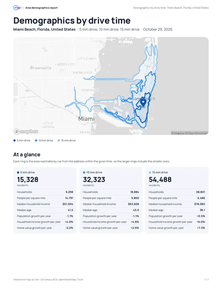
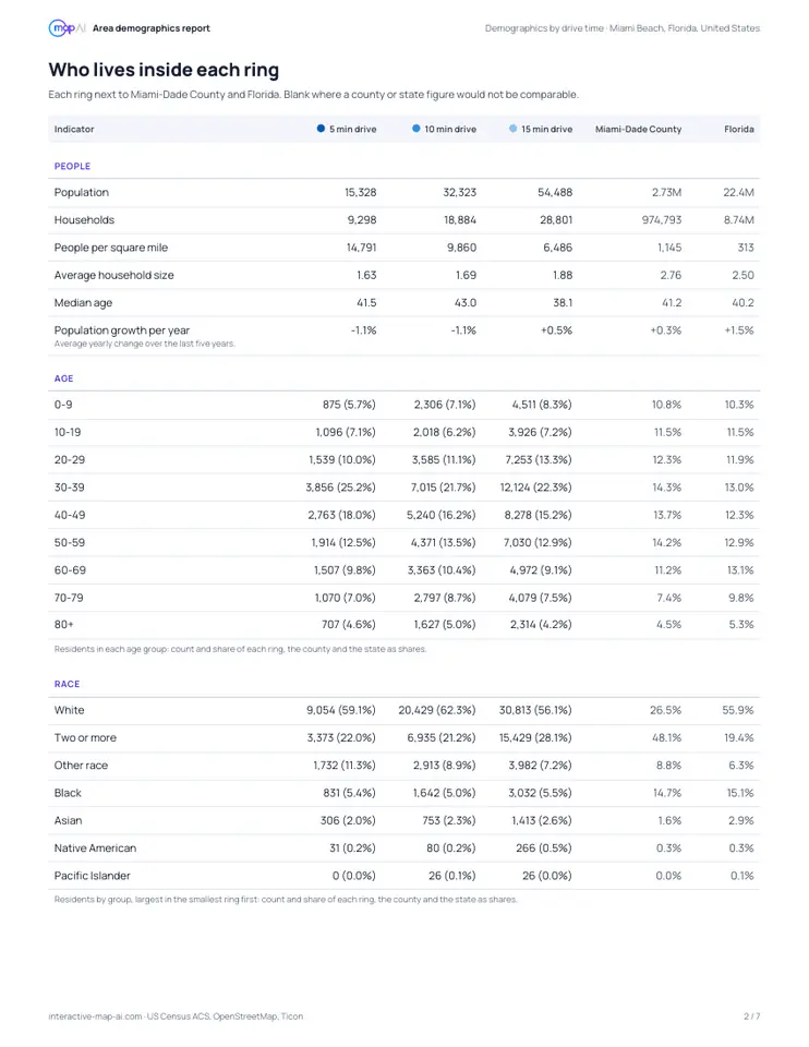
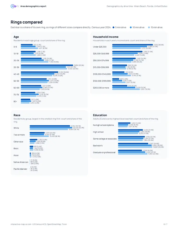
The areas are nested: everyone within a 5-minute drive is also within 10 and 15 minutes. Population always grows outward, and an area’s medians describe everyone inside it, not only the band between two drives.
Hold the population against the shape on the map. A drive that reaches few people for its size means fast roads through empty land; a small area packed with people means a dense, slow city. Either way it is the number of people who can get to you, which a circle cannot tell.
Then hold each area against the county and state columns. A figure well above the county is a strength or a warning, depending on what you sell; one close to it is ordinary for the region. Rates, shares and medians compare directly; totals do not, since a county holds far more people than any ring.
Small areas in rural places hold few people, so their figures carry more survey error. Treat a gap of a few percent there as noise.
%22/%3E%3Cpath d=%22M27.8132 23V24.1139C28.0176 23.9758 28.2267 23.8519 28.4406 23.743C29.4429 23.2273 30.6209 23 31.9242 23C33.4962 23 34.901 23.3225 36.0761 24.0387C36.8233 24.4825 37.4869 25.0889 38.0758 25.8333C38.7043 25.0914 39.4099 24.4875 40.1989 24.0413C41.4461 23.3307 42.8918 23 44.4926 23C45.9086 23 47.2236 23.276 48.4162 23.8501C49.6193 24.4239 50.6148 25.2525 51.3848 26.3286C52.5064 27.8974 53 29.9681 53 32.4109V45H48.1868V32.7029C48.1868 30.8311 47.8289 29.6535 47.3066 28.9706C47.0209 28.5965 46.6312 28.2841 46.1057 28.0444C45.5845 27.8066 45.0126 27.6828 44.3759 27.6828C43.6617 27.6828 43.0095 27.8489 42.4013 28.1802L42.3959 28.1832C41.8014 28.5028 41.3476 28.9306 41.0123 29.4737C40.6521 30.0681 40.3983 31.0936 40.3983 32.7029V45H35.6017V32.6342C35.6017 30.7888 35.2044 29.6351 34.6167 28.9572C33.8808 28.112 32.9403 27.6828 31.6908 27.6828C30.4144 27.6828 29.5268 28.1047 28.8834 28.8838C28.2178 29.6899 27.8132 30.8916 27.8132 32.6342V45H23V23H27.8132Z%22 fill=%22url(%23paint1_linear_5689_33045)%22/%3E%3Cpath d=%22M71.9888 44.9998C70.7374 44.9998 71.1075 45 68.7575 44.9998C67.0804 44.9998 66.2609 45 64.6451 45C61.5903 45 58.9934 44.0905 56.9961 42.0118C54.9986 39.933 54 37.2912 54 34.0866C54 30.7952 55.0721 28.1246 57.2164 26.0748C59.3608 24.025 62.1659 23 65.6322 23C68.9513 23 71.6686 23.9528 73.7835 25.8582C75.9277 27.7349 77 30.2755 77 33.4803V44.9998H71.9888ZM65.5 40.7558C67.3799 40.7558 68.9368 40.1207 70.1704 38.8502C71.4336 37.5799 72.0651 36.0065 72.0651 34.1298V33.6534C72.0651 31.748 71.4923 30.2179 70.3467 29.063C69.2011 27.908 67.6736 27.3307 65.7643 27.3307C63.7962 27.3307 62.1954 27.9515 60.9616 29.1929C59.7279 30.4344 59.111 32.0367 59.111 34C59.111 35.9633 59.7132 37.5799 60.9175 38.8502C62.1219 40.1207 63.6493 40.7558 65.5 40.7558Z%22 fill=%22url(%23paint2_linear_5689_33045)%22/%3E%3Cpath d=%22M83.0112 44.9998C84.2626 44.9998 83.8925 45 86.2425 44.9998C87.9196 44.9998 88.7391 45 90.3549 45C93.4097 45 96.0066 44.0905 98.0039 42.0118C100.001 39.933 101 37.2912 101 34.0866C101 30.7952 99.9279 28.1246 97.7836 26.0748C95.6392 24.025 92.8341 23 89.3678 23C86.0487 23 83.3314 23.9528 81.2165 25.8582C79.0723 27.7349 78 30.2755 78 33.4803V44.9998H83.0112ZM89.5 40.7558C87.6201 40.7558 86.0632 40.1207 84.8296 38.8502C83.5664 37.5799 82.9349 36.0065 82.9349 34.1298V33.6534C82.9349 31.748 83.5077 30.2179 84.6533 29.063C85.7989 27.908 87.3264 27.3307 89.2357 27.3307C91.2038 27.3307 92.8046 27.9515 94.0384 29.1929C95.2721 30.4344 95.889 32.0367 95.889 34C95.889 35.9633 95.2868 37.5799 94.0825 38.8502C92.8781 40.1207 91.3507 40.7558 89.5 40.7558Z%22 fill=%22url(%23paint3_linear_5689_33045)%22/%3E%3Cpath fill-rule=%22evenodd%22 clip-rule=%22evenodd%22 d=%22M78 23H83V55H78V23Z%22 fill=%22url(%23paint4_linear_5689_33045)%22/%3E%3Cpath d=%22M136 50V18.0044L141 18.0241V50H136Z%22 fill=%22%23CCCCCC%22/%3E%3Cpath d=%22M116.719 18L103 50H108.538L112.057 41.8193L114.022 37.1836L119.004 25.5943L123.94 37.1836L125.997 41.8193L129.47 50H135L121.243 18H116.719Z%22 fill=%22%23CCCCCC%22/%3E%3Cdefs%3E%3ClinearGradient id=%22paint0_linear_5689_33045%22 x1=%2268%22 y1=%2234.0001%22 x2=%223.18954%22 y2=%2248.3776%22 gradientUnits=%22userSpaceOnUse%22%3E%3Cstop stop-color=%22%237D40FF%22/%3E%3Cstop offset=%221%22 stop-color=%22%2302A4FF%22/%3E%3C/linearGradient%3E%3ClinearGradient id=%22paint1_linear_5689_33045%22 x1=%221.79289e-06%22 y1=%2234%22 x2=%2268.5%22 y2=%2234%22 gradientUnits=%22userSpaceOnUse%22%3E%3Cstop stop-color=%22%2303A4FF%22/%3E%3Cstop offset=%221%22 stop-color=%22%237E40FF%22/%3E%3C/linearGradient%3E%3ClinearGradient id=%22paint2_linear_5689_33045%22 x1=%222.34962e-06%22 y1=%2234%22 x2=%2267%22 y2=%2233.9626%22 gradientUnits=%22userSpaceOnUse%22%3E%3Cstop stop-color=%22%2302A4FF%22/%3E%3Cstop offset=%221%22 stop-color=%22%237E40FF%22/%3E%3C/linearGradient%3E%3ClinearGradient id=%22paint3_linear_5689_33045%22 x1=%2265.5%22 y1=%2234%22 x2=%22101%22 y2=%2234%22 gradientUnits=%22userSpaceOnUse%22%3E%3Cstop stop-color=%22%237E41FF%22/%3E%3Cstop offset=%221%22 stop-color=%22%237D40FF%22/%3E%3C/linearGradient%3E%3ClinearGradient id=%22paint4_linear_5689_33045%22 x1=%2265.5%22 y1=%2234%22 x2=%22101%22 y2=%2234%22 gradientUnits=%22userSpaceOnUse%22%3E%3Cstop stop-color=%22%237E41FF%22/%3E%3Cstop offset=%221%22 stop-color=%22%237D40FF%22/%3E%3C/linearGradient%3E%3C/defs%3E%3C/svg%3E)